The Cot Burn
in the Toll Park: A short history
Earliest
times: A good place to live with fresh water supplies.
Neolithic/Bronze
age:
The Rock Art cup and ring marks carved on outcrops at the west Binn are
prehistoric, most likely Bronze age. Remarkably, they were not recognised until
discovered by locals in 2002!
There
are also several standing stones in the area. The nearest are a pair in a field
by Glassmount. The standing stones are also thought to be Bronze age.
Other
prehistoric sites on farmland north of the Binn and at west Craigkennochy are
no longer visible.
Iron
age:
There are remains of an ancient hill fort on Dunearn Hill. This is from the
Iron Age and likely raised by local people, not the Romans.
We
can assume that people have lived in the Burntisland area from earliest times. They
would have relied on local burns,
wells and springs for their water
supplies.
Medieval
times: Kirkton: a church built beside the burns.
The
earliest datable part of Burntisland is the Kirkton.
The
Kirkton was mentioned in 1128 as ‘Kinghorn nearer Dunfermline’, then as ‘wester
Kinghorn’ or ‘smaller Kinghorn’. So, a settlement existed there in the 12th
century.
Kirkton
means a settlement by a church. The old church was dedicated to local Fife
saint, St Serf, in 1243, but it is likely that this was a re-dedication and
that there was a church on the site from at least the 12th century. (It
may once have been dedicated to St Adamnan.)
Early
Christian sites were often built on older (pagan) sacred sites. Favoured sites
were by a bend in a stream, or by a confluence of streams, as at the Kirkton where
the Kirkton and Cot Burns join
each other. This confluence is not now obvious as the burns there are in
culverts.
Learn
more about the old church at the Kirkton at: http://www.kirktonoldchurch.org.uk
The
ruins of the old church are worth a visit for an insight into medieval life
locally.
It
is thought that the Castle was built for the Abbots of Dunfermline Abbey. It
was common for the Church to be a main landowner in medieval times. Much of the
income and produce from the local farmland and corn mills probably went to
Dunfermline Abbey.
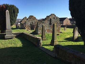
Photo of the old Kirkton church & graveyard in 2021
16th
century: Watermills: the importance of watermills and
the rise of the Royal Burgh.
The
main town of Burntisland developed as a Royal Burgh around the new harbour
built in 1540: the ‘Port of Grace’. While the town grew in importance as a
trading port, the original settlement at the Kirkton remained like a separate country
village.
Corn
mills were essential to their communities to produce flour that everyone relied
upon e.g. to bake bread and pies. Some mills threshed barley for distilleries.
Ged’s
Mill:
In 1559 John Ged bought the corn mill on the north side of the sea inlet
between the Kirkton and the peninsula at Ross Point, from Dunfermline Abbey. The
waters from the Cot and Kirkton
Burns were stored in a mill pond at the Kirkton to control the flow to the waterwheel
at Ged’s Mill. It was still known as Ged’s Mill when it finally closed in the
1920s!
The
sea mill:
Burntisland had another corn mill, which belonged to the Castle estate. This
was on the south side of the sea inlet. It operated for 14 hours per day using
tidal power, the sea turning the waterwheel as it ran in and out of a tidal
pond. The tidal pond remains, now landlocked by land reclamation behind the
west breakwater. The Kirkton
Burn still runs into the tidal pond, but is now diverted around the
‘Alcan Estate’ in a SUDS (Sustainable Urban Drainage System.) The tidal pond is
connected to the sea by a pipe running under the ‘Red Pond’ amenity area. That’s
why the pond water level varies with the tide.
Both
Ged’s Mill and the Sea mill used waterpower from the 16th to the 20th
centuries – over 400 years of green energy!
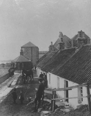
An old photo of Ged’s Mill and cottages looking west from Kirkton Road.
Locals used to call Kirkton Road ‘the Causey’. Presumably it was once a
causeway across the sea inlet that lay between Burntisland (Broomhill &
Ross Point) and the Kirkton.
You can still see that the land is low on each side of Kirkton Road because
it was once reclaimed from the sea.
18th
Century: The Distillery: culverting of the burns
used as water supplies.
The
Grange Brewery opened 1767. It was bought by William Young, from Orwell near
Kinross, around 1786 and converted to a distillery in the 1790s. It used water
piped from Dunearn Loch and from burns
on the west side of the Binn. There was a dispute with the Grange Quarry
owner over the water supplies and the Binn Pond was built as a distillery
reservoir around 1898. The distillery made ‘Old Burntisland’ (O.B.) whisky and
finally closed in 1927. There is a legacy of culverted burns leading to and
from the old distillery. The water leaves the distillery site as the culverted Kirkton Burn to join the culverted Cot
Burn by the site of the old Kirkton mill pond, east of Burntisland
Shipyard AFC football park.
19th
Century: The Victorian age: Country mansions by the
Cot Burn
The
railway came to Burntisland in 1845 with the first train running from Cupar in
1847. Burntisland was the terminus and before the Forth Bridge was built,
passengers and goods crossed the Forth by ferry. The railway changed the town
completely. There was an influx of industry and workers, and the new homes required
meant the town’s expansion beyond its old centre near the harbour. Wealthy
people were also attracted to live here by the pretty countryside, sea views, and
comparatively easy access to the city by train.
Two
new mansions were erected on what was then the edge of town:
Greenmount
was
built south of the Cot Burn in 1859 for Robert Kirke and his family. They had
made their money as owners of sugar plantations in Surinam, which was then a
Dutch colony in South America. They ran their plantations using slave labour.
Greenmount had extensive gardens with heated glasshouses to grow exotic fruit.
In later years, Greenmount became a hotel, but it burnt down in 1987 and was
later demolished.
The
Binn House was built in 1866 on the south slopes of the Binn just north
of the Cot Burn, for Dr David Landale. He was a geologist and mining engineer
for the Wemyss coalfields. By the 1970s the house was ruinous and was demolished
to make way for a housing estate.
20th
& 21st Centuries: A public park and increasing
urbanisation
What
had been fields south of the Binn House and the Cot Burn became a public park:
the East Toll Park, now the Toll Park. There were football pitches, a cricket
pitch, a pavilion, and athletics competitions, including school sports days.
In
the 1950s a housing estate was built on the ‘Widows’ Land’ east of the Toll
Park, and in the 1970s a housing estate was built on what had been the Binn
House estate.
Also
in the 1970s, the Toll Centre, now the Toll Community Centre, was built in the
east end of the Toll Park.
In
2014 the replacement Burntisland Primary School opened, and the school and the associated
playing fields now cover most of the Toll Park.
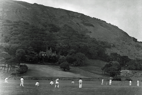
An early photograph of the Toll Park with a cricket match being played.
The Binn House with its estate and kitchen garden is seen in the background on
the slopes of the Binn.
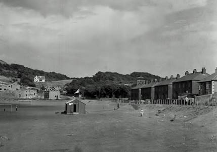
An interesting photo of the Toll Park showing the pavilion with its flag,
and a football pitch. Note the houses being built at the Widows’ Land estate. This
would date the photo to the early 1950s. The white Golf Club House is seen in
the distance and the Greenmount Hotel with its belvedere is peeping out from
the trees beyond the houses on the right.
What’s
in a name? Cot Burn and Toll Park: The Great North Road link
Names
change over the years and often the original meaning is lost. However, place
names can give clues to local history.
Cot Burn: The Cot Burn rises on the east side of the Binn near the
golf course. It now runs in a culvert from there to the Toll Park, and again in
a culvert from the Toll Park to join the Kirkton Burn in a culvert at the site
of the old mill pond near Glebe Place.
Cot
means a cottage, and burn, of course, means a small stream. As the golf course
used to be farmland, there may have been a farm workers’ cottage that gave the
burn its name.
Toll Park: Until the agricultural and industrial
revolutions, most roads outside of towns were just unmade dirt tracks. These
would become rutted and muddy in wet weather making travel slow and difficult
for wheeled carts drawn by horses, or other draught animals.
The
1753 Turnpike Act proposed a new road be constructed between Edinburgh and
Perth, and eventually, Inverness. This was the Great North Road (GNR). The main
route used ferries to cross the Forth at Queensferry. However, the ‘Broad
Crossing’ to the good harbour at Burntisland was an alternative. A branch road
was built to link Burntisland harbour with the GNR at Cowdenbeath. This GNR Burntisland
branch is the line of the current A909 road between Burntisland and the ‘Juck’
on the Cowdenbeath Road. At one of the now ruined and ivy covered cottages at
Loftheads at the Juck, the ‘Duck Inn’ once offered refreshments to travellers!
The
funds to build and maintain the turnpike roads were raised on the value of
goods carried and these tolls were paid at a Toll Bar. There were two Toll Bars
in Burntisland: the Kirkton Toll on Aberdour Road and East Toll at the junction
with Cowdenbeath Road. The park was named after this East Toll, originally East
Toll Park, now just the Toll park.
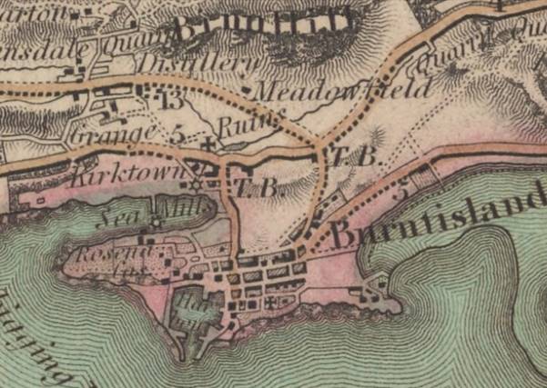
The map extract below is from James Fraser’s map of the Counties of Fife
and Kinross and is reproduced with the permission of the National Library of
Scotland.
The map was drawn before the railway came to
Burntisland. It shows that even in the mid 19th century, Burntisland
was still a small town, clustered around the harbour, the Port of Grace.
Kirkton still looks like a separate village.
Of note are:
·
Ged’s Mill and the Sea Mill, each shown with a
little star symbol to represent a waterwheel.
·
Both the old church at the Kirkton (marked as
‘Ruins’) and the main Parish Church are shown with a cross symbol.
·
Kirkton and East Toll are marked T.B. for Toll Bar.
·
The Cot Burn is clearly shown running from its
source near a marked ‘Quarry’ to the Kirkton Mill Pond. There it is shown
joined by the burn from the ‘Distillery’, close to the old church. A little
line indicates the burn flow to Ged’s Mill, then the sea.
Note the shape of the town with the Binn behind,
the rocky peninsulas at Lammerlaws and Rossend, with the sea inlet where the
mills stand. The sandy bay and the old pier at the foot of Lochie’s Road can be
seen (just above the word ‘Burntisland’, right of the ‘5’) and Lochies
House, now the Sands Hotel, beside it. Note also the old roads and lanes
predating the roads (coloured orange) that are still our main roads today.
You can learn more about the history of our town
and its history from Burntisland Heritage Trust publications:
Burntisland Port of Grace by Iain Sommerville with
Ian Archibald & Helen Mabon
This describes the development of the town and
includes: a timeline, notes from James Speed’s compilation from the old Burgh
Records, drawings, maps, and photographs, including one of local artist Andrew
Young’s painting of the Sea Mill in 1921. This painting hangs in Burntisland
Burgh Chambers.
Burntisland A Social History by Iain Sommerville
This includes information on previous local
industries including the distillery, shale mining and oil works, and the
aluminium works.
It focusses on well known previous locals including
the Kirke family of Greenmount and the Landale family of the Binn House.
It is illustrated with old photographs and includes
reminiscences from older residents of the town around the millennium.
Burntisland Voices edited by Iain Sommerville
This is an oral history with excerpts from
interviews from residents of the 20th century.
It includes a chapter on the Binn Villages.
More information is available on scheduled ancient
monuments from Historic Environment Scotland. Use their map search portal to
find out about our local ancient sites: https://hesportal.maps.arcgis.com/apps/Viewer/index.html?appid=18d2608ac1284066ba3927312710d16d