|
|

Modern
Maps Derived from
Ordnance Survey OpenData
Site navigation - please use menu on left (click here to display it if not visible). If problems, use site map.
|
Modern
Maps Derived from Site navigation - please use menu on left (click here to display it if not visible). If problems, use site map. |
The maps on this page (and those available from links on this page) are derived from Ordnance Survey OpenData. They are all subject to the attribution: "Contains Ordnance Survey data © Crown copyright and database right 2010".
The terms of the Ordnance Survey licence allow you to download, copy and adapt the maps for your own use. Please click here to see the full licence (opens in a new tab or window).
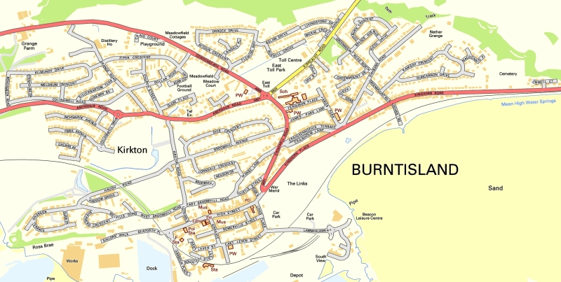
Errors spotted on the maps: Linwell Court is shown as "INWELL CT"; "KINGHORN PLACE" is actually the western section of Kinghorn Road.
(1) Burntisland area map
The map of Burntisland and the surrounding area is shown below. As the detail is indistinct, it is intended only as an overview. Please click on the map for a larger scale version (0.9Mb) , which will open in a new tab or window. You can also download a relatively high resolution A4 version in PDF format by clicking here (1.4Mb, opens in a new tab or window); this one gives good results when printed (check your printer setting is "Landscape").

(2) Burntisland street map
The map of Burntisland streets is shown below. As the detail is indistinct, it is intended only as an overview. Please click on the map for a larger scale version (1Mb) , which will open in a new window. You can also download a relatively high resolution A4 version in PDF format by clicking here (0.9Mb, opens in a new tab or window); this one gives good results when printed (check your printer setting is "Landscape").
Webpage by Iain Sommerville;
Help
on bookmarking this page.